logo

An American Family History

Samuel Smith

The State of Franklin was an unrecognized, independent state in what is now eastern Tennessee. It was created in 1784 with the intent of becoming the fourteenth state. Its first capital was Jonesborough. It existed for about four and a half years and then North Carolina re-assumed control.

Samuel Smith was born about 1755.

He married his cousin, Mary Smith.

Samuel Smith (1780),
George Smith (1784)
Jacob Smith (1785)
James Smith

In 1777 a Samuel Smith signed the 1777 Petition of Holston Men.

In 1779 a Samuel Smith was a Justice of the Peace in Sullivan County Tennessee.

In 1780, he was appointed to be a justice of the peace in Sullivan County, Tennessee.

March 20, 1787 a conference was held at Samuel Smith, Esq.'s house between Evan Shelby and John Sevier concerning the State of Franklin.

In 1781 Zebulon Smith substituted for Samuel in the militia.

Samuel Smith received land grants in Sullivan County, Tennessee:
1057 and 1086 in 1782
1446 in 1788

In 1786, Hawkins County was taken from Sullivan County, Tennessee. A Commission including Joseph Martin, James McNeil, John Duncan, William King, Evan Shelby, Samuel Smith, and John Scott were selected to find a site for the county courthouse. Apparently, they did nothing about it, and a new commission was named in 1795. (from Historical Sketches, Volume 10, 1976 by The Historical Society of Southwest Virginia)

In 1791 Samuel received a land grant in Hawkins County.


divider

 
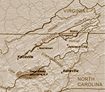
The Holston River flows from Kingsport to Knoxville.
map
map by Kmusser

To all to whom these presents shall come greeting Know ye that we for and in Consideration of the sum of fifty shillings for every hundred acres here by granted paid into our treasury by Samuel Smith have given and granted and by these presents do give and grant unto Samuel Smith a tract of land Containing two hundred fifty [250] acres lying and being in our County of Sullivan on the south side of Holsten river joining his first survey

  • Begining at a pine and black oak on his own line
  • thence south thirty four West one hundred poles to a dogwood pine and Sowerwood
  • thence North sixty seven West two hundred and eighty poles to a stake
  • thence north forty East one hundred and ninty two poles to his Corner duble Chesnut on the top of a ridge thence south forty five East two hundred and eighty poles to the Begining

as by the plat hereunto annaxed doth appear together with all woods waters mines minerals hereditaments and appurtenances to the sd land belonging or appertaining to hold to the sd Samuel Smith his heirs and assigns forever

yealding and paying to us such sums of mony yearly or otherwise as our General assembly from time to time may direct provided allways that the sd Samuel Smith shall cause this grant to be registered in the Registers office of our sd County of Sullivan within twelve months from the date hereof otherwise the same shall be void and of no effect

in Testimony whereof we have Caused our great seal to be hereunto affixed Witness Alexander Martin Esq our govenor Captin General and Commander in Chief at Fairfield the twenty third day of October in the seventh year of our Independence and in the year of our Lord one thousand seven hundred and eighty two [1782]


To all to whom these presents shall come greeting Know ye that we for and in Consideration of the sum of fifty shillings for every hundred acres here by granted paid into our treasury by Samuel Smith have given and granted and by these presents do give and grant unto Samuel Smith a tract of land Containing six hundred and thirty acres [630]

lying and being in our County of Sullivan on the south side of Holston River on hickory Creek

    • begining at two White Oaks on the side of a ridge
    • thence on Doctor Sholts line north forty five West thirty eight poles to a white oak Sholts Corner at his fence
    • thence north thirty East fifty two poles to a hickory and white oak
    • thence along Shoalts line north six East one hundred and six poles to a white oak on John Webbs line
    • thence on sd line north sixteen west twenty poles to two small white oaks
    • thence on sd line north sixty eight west three hundred and thirty four poles to a white oak
    • thence along Wevers line south forty seven west two hundred and twenty six poles to a [poplar] and white oak
    • thence south fifty four East twenty poles to a red oak south sixty eight east sixty poles to a duble Chesnut on the top of a ridge
    • thence south forty five East three hundred and forty poles to two white oaks
    • thence north fifty East sixty six poles to a stake thence a strait Cose to the Begining
As by the plat here unto annaxed... and in the year of our Lord one thousand seven hundred and eighty two [1782]


To all to whom these presents shall come greeting Know ye that we for and in consideration of the sum of fifty shillings for every hundred acres hereby granted paid into our treasuary by Samuel Smith have given and granted and by these presents Do give and grant unto the said Samuel Smith a tract of Land containing fifty seven acres [57] lying and being in our County of Sullivan joining Solomon Smith and John Rileys Lands including the plantation where Caleb Odle formerly lived
  • Begining at Solomon Smiths Corner white oak
  • then along Smiths line west thirty six poles to a sugar tree at the Creek
  • then along a high nob South thirty eight poles to an ash tree
  • then along said nob South twenty six Degrees west ninety six poles to a hicory tree
  • then along said nob South three Degrees east forty eight poles
  • to John Rileys corner black walnut tree on the creek
  • then along Rileys Line East seventy six poles to a stake thence north one hundred and fifty two poles to the Begining
as by the plat hereunto annexed ... and in the year of our Lord one thousand seven hundred and eigthy eight [1788]


This Indenture Made this third Day of October in the year of our Lord one thousand Seven hundred and Eighty five [1785] between Samuel Smith of Sullivan County & State of North Carolina of the one part and William McKinley of the County & State aforesaid of the other part

Witnesseth that the said Samuel Smith for and In Consideration of the Sum of thirty pounds good & Lawfull money of the State aforesaid to him in hand paid by the said William McKinley the Receipt whereof he the Samuel Smith doth hereby acknowledge hath granted bargained and sold and by these presents Doth grant Bargain & sell Alien Convey and Confirm unto the said William McKinley his heirs and assigns forever a certain tract or parcel of land containing seventy five [75] acres be the same more or less Situate Lying and begin within County and State aforesaid

  • Beginning at a white oak Henry Waggeners Corner
  • thence north fifty East two hundred and twenty poles to a poplar & white oak Runing along Thomas Smallings line
  • thence north thirty west fifty four poles to said Samuel Smiths Corner a black oak tree
  • thence south fifty west two hundred and thirty two poles to a white oak and poplar on Wagoners line
  • thence South fifty five East four poles to the beginning


Colonial Maryland
Colonial New England
Colonial Virginia & West Virginia
Quakers & Mennonites
New Jersey Baptists
 
German Lutherans
Watauga Settlement
Pennsylvania Pioneers
Midwest Pioneers
Californians
Jewish Immigrants

©Roberta Tuller 2020
tuller.roberta@gmail.com
An American Family History is a participant in the Amazon Services LLC Associates Program,
an affiliate advertising program designed to provide a means for sites to earn advertising fees by advertising and linking to Amazon.com.
As an Amazon Associate, I earn from qualifying purchases.